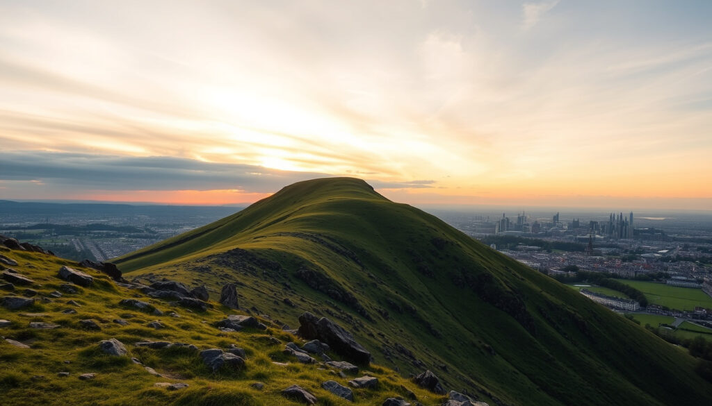
Arthurs Seat – Complete Guide to Edinburgh’s Ancient Volcano
Rising 251 metres above the streets of Edinburgh, Arthur’s Seat is the centrepiece of Holyrood Park and the remains of an ancient volcano. This guide covers the walking routes, history, geology, and practical advice for anyone planning to visit the summit.
Arthur’s Seat is part of a group of hills that includes Salisbury Crags. The entire area has been designated a Site of Special Scientific Interest (SSSI) due to its geological and ecological value. Whether you are a hiker, a photographer, or a history enthusiast, the hill offers something for everyone.
The summit provides panoramic views of Edinburgh’s skyline, the Firth of Forth, and the Pentland Hills. With multiple routes of varying difficulty, the walk is accessible to most fitness levels. Below is a quick overview of the key facts.
Why Is It Called Arthur’s Seat?
| Attribute | Detail |
|---|---|
| Height | 251 metres (823 ft) |
| Type | Extinct volcano (Carboniferous) |
| Location | Holyrood Park, Edinburgh |
| Walk Time | 30 minutes to 1 hour (summit from base) |
Key Insights
- Arthur’s Seat is not just a hill but the remains of a volcano that erupted over 340 million years ago.
- Despite its name, there is no definitive historical evidence linking it directly to King Arthur; the name likely originated from later medieval legend or a corruption of ‘Ard-na-Said’ (Gaelic for ‘height of the arrows’).
- The summit offers panoramic views of Edinburgh, the Firth of Forth, and beyond, making it a must-visit for photographers and hikers.
- Multiple routes cater to different fitness levels: the easiest is the grassy slope from the Dunsapie Loch car park; the most direct is from the Palace of Holyroodhouse.
- Arthur’s Seat is part of a group of hills that include Salisbury Crags, and the entire area is a Site of Special Scientific Interest (SSSI).
Snapshot Facts
| Attribute | Detail |
|---|---|
| Highest point | 251 m (823 ft) |
| Prominence | 186 m (610 ft) |
| Location | Edinburgh, Scotland |
| Parent peak | None (isolated hill) |
| OS grid reference | NT275732 |
| Topo map | OS Landranger 66 |
| Age of rock | Carboniferous (c. 340 million years) |
| Last eruption | Extinct – no activity for millions of years |
The name “Arthur’s Seat” has been a subject of debate for centuries. Wikipedia notes that the earliest recorded reference dates to around 1360. Theories about the origin include a corruption of the Gaelic “Ard-na-Said” (height of the arrows), a connection to the legendary King Arthur, or even a local chieftain named Arthur. No direct archaeological evidence links the hill to the mythic king, so the mystery remains open.
How Tall Is Arthur’s Seat and Is It a Volcano?
Arthur’s Seat stands 251 metres (823 feet) above sea level, making it the highest point in Holyrood Park. Geologically, it is an extinct volcano that last erupted during the Carboniferous period, around 340 million years ago. The visible remains include two distinct vents known as the Lion’s Head and the Lion’s Haunch.
Historic Environment Scotland describes Holyrood Park as dominated by this ancient volcanic site. The hill’s core is a volcanic plug – magma that solidified within the volcano’s vent. Softer surrounding rock eroded over millions of years, leaving the resistant core we see today.
Although called a volcano, Arthur’s Seat is a classic volcanic plug. The last eruption occurred so long ago that the cone has completely eroded away. What remains is the hardened magma conduit.
Formation and Landscape
Glacial activity during the Ice Ages shaped the landscape further, exposing the volcanic neck and carving the surrounding crags. The result is a distinctive skyline visible from most of Edinburgh. Salisbury Crags, the prominent basalt cliffs to the west, are part of the same volcanic system.
What Are the Best Walking Routes to the Summit?
There are four main colour-coded routes to the summit, each offering a different experience. The Walkhighlands guide provides detailed descriptions and maps. Here is a summary of the main options:
- Red Route (Moderate) – Follows an ancient lava flow from the Royal Mile near Holyrood Palace. Starts at Broad Pavement.
- Blue Route (Gentle) – Passes through Hunter’s Bog and joins the Red Route near Salisbury Crags. A more gradual ascent.
- Green Route (Easy) – A shorter path crossing grassy slopes and ancient terraces. Ideal for beginners.
- Purple Route (Steeper) – A direct ascent from Holyrood Park Road near Pollock Halls. Challenging but quick.
A popular circular walk starts and ends at the Scottish Parliament, passing St Margaret’s Loch and the ruins of St Anthony’s Chapel (14th century). For those wanting an easier option, driving to Queen’s Drive parking near St Margaret’s Loch provides a short path to the summit.
The summit is often exposed to strong winds. Even on a calm day in Edinburgh, gusts at the top can be much stronger. Check the City of Edinburgh Council website for weather advisories before heading out.
Difficulty and Duration
The walk is rated Easy to Moderate. Most people take between 30 minutes and 1 hour to reach the summit from the base. Allow about 2 hours total if you plan to stop for photos, a picnic, or to explore side paths. The AllTrails page includes user reviews and up-to-date trail conditions.
What Is the History of Arthur’s Seat?
The area has been inhabited for thousands of years. During the Iron Age (around 2,000 years ago), a hill fort was built on the summit and slopes. Evidence of ancient settlements can still be seen in the form of terraces and earthworks.
In the medieval period, Holyrood Park was established as a royal hunting ground. The hill appears in literature as early as 1360. By the 19th century, Arthur’s Seat had become a popular destination for Romantic poets and writers. Robert Louis Stevenson wrote about the hill in his book “Edinburgh: Picturesque Notes” (1879), describing it as “a hill for magnitude, a mountain in virtue of its bold design.”
The hill is also mentioned in Mary Shelley’s “Frankenstein.” Local folklore includes tales of King Arthur and a sleeping dragon. One May Day tradition involved maidens washing their faces in the morning dew on the hill for good luck.
The connection between Arthur’s Seat and King Arthur is unsubstantiated. While the name suggests a link, no historical records or archaeological finds support the idea. The true origin of the name remains a matter of debate.
How Do I Get to Arthur’s Seat and What Facilities Are Available?
Directions
- From the Royal Mile – Enter next to Holyrood Palace. The Red and Blue routes start here.
- From Pollock Halls / Commonwealth Pool – Use the Holyrood Park Road entrance for the Purple route.
- Public Transport – Lothian Buses No. 35 stops at Canongate Kirk, a short walk from the start.
- Parking – Queen’s Drive parking costs £1 per hour (free on weekends). Spaces fill quickly in summer.
Facilities and Tips
Holyrood Park is free and open year-round. There are no toilets or cafes on the summit, so plan ahead. The best months for a visit are May to October, when the weather is milder. Early mornings and weekdays are quieter, especially during peak tourist season.
How Has Arthur’s Seat Changed Through the Ages?
- ~340 million years ago – Volcanic eruption forms the core of Arthur’s Seat.
- Ice Ages (last ~2 million years) – Glaciers sculpt the landscape, exposing the volcanic neck.
- 2,000 years ago (Iron Age) – Hill fort settlements built on the summit and slopes.
- Medieval era – The name ‘Arthur’s Seat’ first appears in records (earliest reference c. 1360).
- 16th century – Holyrood Park established as a royal hunting ground.
- 19th century – Robert Louis Stevenson writes about Arthur’s Seat; becomes popular with Romantic poets and tourists.
- 20th century – present – Protected as part of Holyrood Park for public recreation and conservation.
What Is Known and What Remains Uncertain About Arthur’s Seat?
| Established Facts | Uncertainties and Legends |
|---|---|
| Arthur’s Seat is the summit of a group of hills in Holyrood Park. | The origin of the name ‘Arthur’s Seat’ is not definitively known. |
| It is an extinct volcano, last active about 340 million years ago. | Whether King Arthur ever visited the hill is unsubstantiated. |
| Its height is 251 metres (823 ft). | Alternative theories suggest a Gaelic or Pictish origin for the name. |
| It is located within the city of Edinburgh, Scotland. | The identity of ‘Arthur’ remains a matter of debate among historians. |
| There are multiple clearly marked walking routes. | Local myths include a sleeping dragon and connections to Mary Shelley’s Frankenstein. |
What Is the Geological and Cultural Significance of Arthur’s Seat?
Geologically, Arthur’s Seat is a textbook example of a volcanic plug. Its formation and subsequent erosion have shaped Edinburgh’s landscape in a way that few other urban hills can match. The site is protected as an SSSI for its rare rock exposures and plant communities.
Culturally, the hill appears in works by Robert Louis Stevenson and Sir Walter Scott. It has long been a recreational hub for locals and a must-see for tourists. The mystery surrounding its name only adds to its appeal. The Britannica entry summarises its importance as a landmark that blends natural history with human curiosity.
What Do Writers and Historians Say About Arthur’s Seat?
“Arthur’s Seat is a hill for magnitude, a mountain in virtue of its bold design.”
Robert Louis Stevenson, ‘Edinburgh: Picturesque Notes’ (1879)
“It is the main peak of a group of hills in Edinburgh, Scotland, which form most of Holyrood Park.”
Wikipedia – Arthur’s Seat
“Dominated by the iconic Arthur’s Seat, this ancient volcanic site offers stunning views of the city and beyond.”
Historic Environment Scotland – Holyrood Park
What Is the Best Way to Experience Arthur’s Seat?
A visit to Arthur’s Seat is straightforward and rewarding. Choose a route that matches your fitness, check the weather beforehand, and allow time to explore the surrounding Holyrood Park. After the climb, consider visiting the nearby Holyrood Park guide for more details on the area, or explore Edinburgh walking routes for other trails in the city. For those interested in other destinations, the Sri Lanka – Capital, Religion, Language, and Key Facts article and the El Salvador – Essential Facts on Capital, Food and Safety guide offer travel information from around the world.
Frequently Asked Questions
Where can I find a map of Arthur’s Seat?
Maps are available at the Holyrood Park information centre and online on the Historic Environment Scotland website. The Walkhighlands site also provides a detailed route map.
How long does the Arthur’s Seat walk take?
Depending on your fitness and route, the walk from the base to the summit takes between 30 minutes and 1 hour. Allow extra time for photos and enjoying the view.
Is Arthur’s Seat suitable for beginners?
Yes. The easiest route starts from Dunsapie Loch car park and follows a gentle grassy slope. Some paths are steep and rocky, so choose a route that matches your ability.
Can I see Arthur’s Seat from the city centre?
Yes, Arthur’s Seat is visible from many points in Edinburgh, especially from the Royal Mile and Princes Street gardens.
Is there an entrance fee for Arthur’s Seat?
No, Holyrood Park is free and open to the public all year round. Car parking is free but can fill quickly.
Are dogs allowed on Arthur’s Seat?
Yes, dogs are welcome in Holyrood Park but must be kept under control, especially near livestock (sheep) sometimes present.
More related posts
 Keir Starmer – Biography, Family, Approval Rating and Resignation
 Stuck in the Middle – TV Series Cast and Song Guide
 Jamie Campbell Bower – Biography, Vecna Role, and 2025 Updates
 Kareem Abdul-Jabbar – Height, Net Worth, Family and Books
 High Interest Savings Account – Top UK Rates 2025
 Amelia Bullmore – Biography, TV Shows, and Personal Life
 Leeds United vs Arsenal F.C. – Match Preview and Key Stats
 Cadair Idris – Complete Hiking Guide with Routes and Safety Tips
